Estimate the soil depth of a single profile within a SoilProfileCollection object. This function would typically be called by profileApply().
Usage
estimateSoilDepth(
  f,
  name = hzdesgnname(f),
  p = "Cr|R|Cd",
  selection = min,
  no.contact.depth = NULL,
  no.contact.assigned = NULL
)
Arguments
- f
SoilProfileCollection object of length 1, e.g. a single profile
- name
name of the column that contains horizon designations
- p
REGEX pattern for determining "contact", or depth to some morphologic feature (e.g.
Bt)- selection
an R function applied in the presence of multiple matching horizons:
min(default),max,mean, etc.- no.contact.depth
in the absence of contact matching
p, a depth at which we can assume a standard depth-to-contact- no.contact.assigned
value assigned when no contact is encountered at or below
no.contact.depth
Details
The choice of a selection function usually follows:
min: the top of the first matching horizon, max: the top bot the last matching horizon,
or possibly mean: somewhere in-between.
Examples
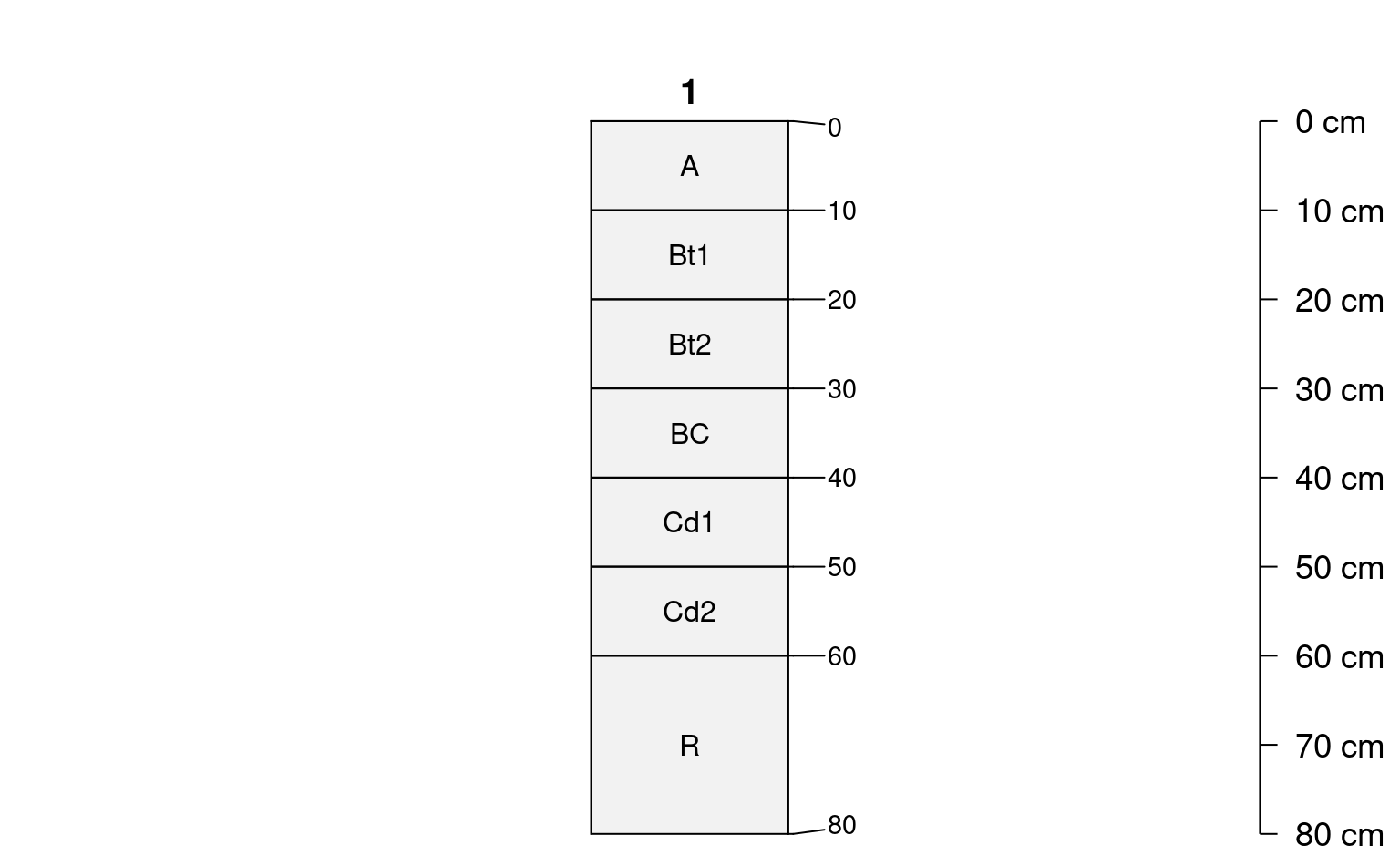
## consider a situation where there were multiple candidate
## "contacts": 2 Cd horizons over an R
# init hypothetical profile
d <- data.frame(
id = '1',
top = c(0, 10, 20, 30, 40, 50, 60),
bottom = c(10, 20, 30, 40, 50, 60, 80),
name = c('A', 'Bt1', 'Bt2', 'BC', 'Cd1', 'Cd2', 'R'),
stringsAsFactors = FALSE
)
# upgrade to SPC
depths(d) <- id ~ top + bottom
# init horizon designation
hzdesgnname(d) <- 'name'
# visual check
par(mar = c(0, 0, 0, 2))
plotSPC(d, hz.depths = TRUE, name.style = 'center-center', cex.names = 1, width = 0.1)
 # top of the first Cd
estimateSoilDepth(d, name = 'name')
#> [1] 40
# top of the first Cd
estimateSoilDepth(d, name = 'name', selection = min)
#> [1] 40
# top of the R
estimateSoilDepth(d, name = 'name', selection = max)
#> [1] 60
# top of the second Cd
estimateSoilDepth(d, name = 'name', selection = max, p = 'Cd')
#> [1] 50
## another example
data(sp1)
depths(sp1) <- id ~ top + bottom
# init horizon designation
hzdesgnname(d) <- 'name'
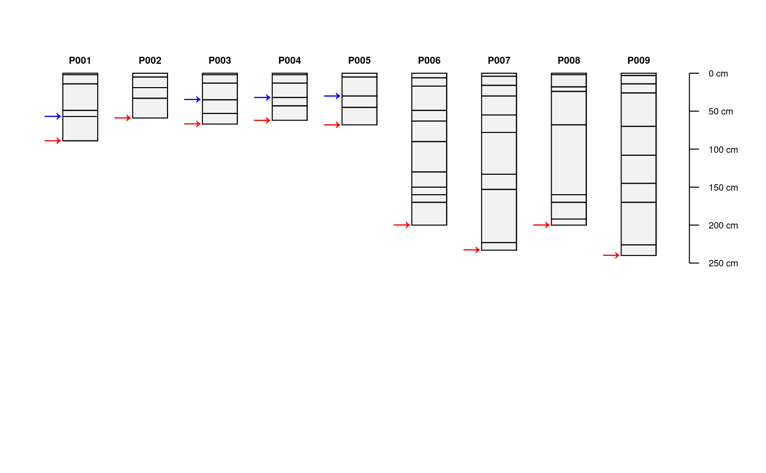
# apply to each profile in a collection, and save as site-level attribute
sp1$depth <- profileApply(sp1, estimateSoilDepth, name='name')
# this function can be used to "find" depth to any feature
# that can be defined via REGEX pattern matching on the horizon name
# for example, locate the depth to the top "Bt" horizon
# returning NA when there is no match
sp1$top_Bt <- profileApply(
sp1, estimateSoilDepth,
name='name',
p='Bt',
no.contact.depth=0,
no.contact.assigned=NA
)
# reduced margins
par(mar=c(1,1,1,2))
# adjust default y-offset and depth scaling for following examples
plotSPC(sp1, y.offset=10, scaling.factor=0.5)
# get plotting parameters for profile widths and depth scaling factors
lsp <- get("last_spc_plot", envir = aqp.env)
# positions on x-axis, same for both depth and top "Bt" horizon
x.positions <- (1:length(sp1)) - lsp$width
# annotate contact with unicode right-arrow
# y-position is adjusted based on plot y-offset and scaling factor
y.positions <- lsp$y.offset + (sp1$depth * lsp$scaling.factor)
text(x.positions, y.positions, '\u2192', col='red', adj=1, cex=1.25, lwd=2)
# annotate top "Bt" depth with unicode right-arrow
# y-position is adjusted based on plot y-offset and scaling factor
y.positions <- lsp$y.offset + (sp1$top_Bt * lsp$scaling.factor)
text(x.positions, y.positions, '\u2192', col='blue', adj=1, cex=1.25, lwd=2)
# top of the first Cd
estimateSoilDepth(d, name = 'name')
#> [1] 40
# top of the first Cd
estimateSoilDepth(d, name = 'name', selection = min)
#> [1] 40
# top of the R
estimateSoilDepth(d, name = 'name', selection = max)
#> [1] 60
# top of the second Cd
estimateSoilDepth(d, name = 'name', selection = max, p = 'Cd')
#> [1] 50
## another example
data(sp1)
depths(sp1) <- id ~ top + bottom
# init horizon designation
hzdesgnname(d) <- 'name'
# apply to each profile in a collection, and save as site-level attribute
sp1$depth <- profileApply(sp1, estimateSoilDepth, name='name')
# this function can be used to "find" depth to any feature
# that can be defined via REGEX pattern matching on the horizon name
# for example, locate the depth to the top "Bt" horizon
# returning NA when there is no match
sp1$top_Bt <- profileApply(
sp1, estimateSoilDepth,
name='name',
p='Bt',
no.contact.depth=0,
no.contact.assigned=NA
)
# reduced margins
par(mar=c(1,1,1,2))
# adjust default y-offset and depth scaling for following examples
plotSPC(sp1, y.offset=10, scaling.factor=0.5)
# get plotting parameters for profile widths and depth scaling factors
lsp <- get("last_spc_plot", envir = aqp.env)
# positions on x-axis, same for both depth and top "Bt" horizon
x.positions <- (1:length(sp1)) - lsp$width
# annotate contact with unicode right-arrow
# y-position is adjusted based on plot y-offset and scaling factor
y.positions <- lsp$y.offset + (sp1$depth * lsp$scaling.factor)
text(x.positions, y.positions, '\u2192', col='red', adj=1, cex=1.25, lwd=2)
# annotate top "Bt" depth with unicode right-arrow
# y-position is adjusted based on plot y-offset and scaling factor
y.positions <- lsp$y.offset + (sp1$top_Bt * lsp$scaling.factor)
text(x.positions, y.positions, '\u2192', col='blue', adj=1, cex=1.25, lwd=2)
 if (FALSE) { # \dontrun{
# sample data
data(gopheridge, package='soilDB')
# run on a single profile
estimateSoilDepth(gopheridge[1, ], name = 'hzname')
# apply to an entire collection
profileApply(gopheridge, estimateSoilDepth, name = 'hzname')
} # }